Corporate Aid Tracker

When disasters strike, businesses mobilize their expertise, capabilities, and community resources to assist with the relief and recovery efforts. The U.S. Chamber of Commerce Foundation's Disaster Corporate Aid Tracker serves as the keeper of the records for the business community's response to disasters.
Is your company providing aid?
Access our online form to submit your information to a Corporate Aid Tracker.

The Corporate Aid Tracker is an essential platform for showcasing our commitment to disaster recovery. It allows us to share our initiatives and learn from the best practices of other companies, ensuring we make a meaningful difference.— Patty Riddlebarger, vice president of corporate social responsibility, Entergy
By using the Corporate Aid Tracker, we’ve been able to share our contributions and better coordinate with other organizations. It helps Walmart get essential resources where they’re needed most, allowing us to respond to disasters with greater speed and impact effective.— Brooks Nelson, director of disaster preparedness and response, Walmart.org

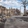
Flooding in Central Texas & Hill Country
This page will provide up-to-date guidance and resources to help the business community effectively contribute to response efforts following flooding in Central Texas and Hill Country.
2025
2024
2023
2022
2021
2020
2019
Latest Content
- The U.S. Chamber of Commerce and the U.S. Chamber Foundation convened private-public leaders for a briefing on October 12 to share live updates on the ground, what the most immediate needs are, and ways the private sector can help.On August 8, 2023, a series of wildfires broke out in Hawaii. Affecting Maui and other island communities, the wind-driven fires have led to mass evacuations, widespread damage, and numerous lives lost.UPS, Meta, Google, Abbott, and Medtronic cross-sector response highlightsSix weeks after a series of devastating earthquakes struck Türkiye and Syria, the U.S. Chamber of Commerce Foundation led two discussions during the U.S.-Türkiye Business Forum: Prioritizing Resilient Partnerships, convened with the U.S. Chamber’s U.S.-Türkiye Business Council on March 13. As the region begins to focus on recovery to meet humanitarian needs, this creates opportunities for strengthening relationships and building stronger, more resilient communities.The U.S. Chamber of Commerce Foundation recently convened cross-sector leaders to discuss the state of Ukraine’s ongoing humanitarian crisis, commemorating one year since the Russian invasion.The U.S. Chamber of Commerce Foundation today launched private-public coordination efforts to help the areas impacted by the earthquakes in Türkiye and Syria. This includes a corporate aid tracker currently showing pledges from the U.S. business community totaling more than $33.1 million.Due to our systemic interdepedence, extreme events have greater implications to the marketplace broadly, communities, and individuals daily on a more intimate level globally. Rob Glenn, vice president of Global Resilience at the U.S. Chamber of Commerce Foundation outlines how we can consider developing stabilizing solutions together.